FAQ's
What is the WPCI?
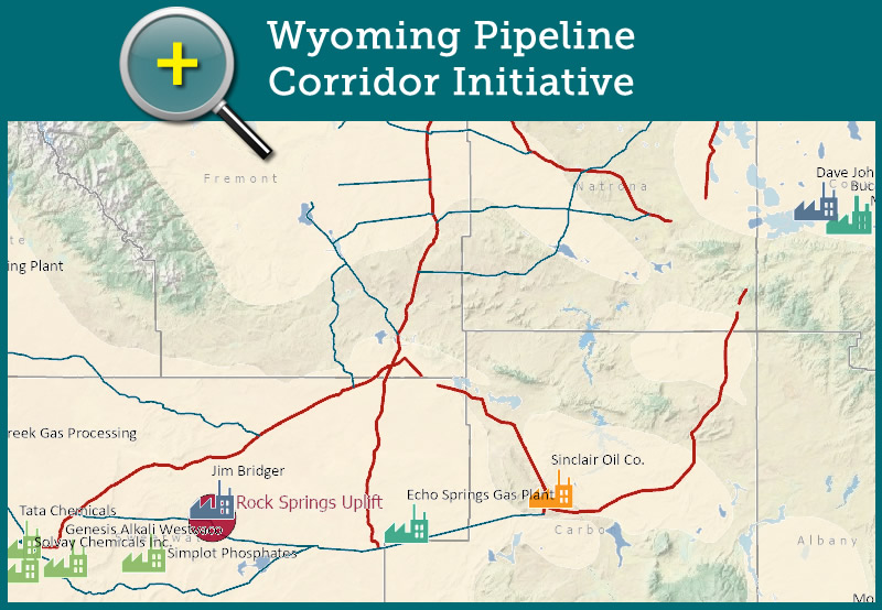
The Wyoming Pipeline Corridor Initiative (WPCI) is a set of corridors to accommodate future pipeline rights-of-way (ROW) designed to connect sources of carbon dioxide (CO2) to existing oil fields suitable for enhanced oil recovery (EOR) via CO2 flooding.
What is the purpose of the WPCI?
The WPCI is intended to address the need for pipeline infrastructure within Wyoming that would transport CO2 and associated products. By establishing corridors on federal lands, companies that wish to construct pipelines in the WPCI will be able to do so with shorter timetables as a large portion of the federal planning process is completed. Additionally, by consolidating infrastructure within the WPCI, impacts to other resources are minimized.
What is enhanced oil recovery?
Enhanced oil recovery (EOR) is the process of obtaining stranded oil not recovered from an oil reservoir through conventional extraction processes.
Who were the responsible parties in the WPCI planning process?
The Wyoming Pipeline Authority (WPA), now known as the Wyoming Energy Authority (WEA), was the main proponent of the project. The State of Wyoming acted as the co-lead in the planning process. The State of Wyoming served as the project manager for the federal planning process, in coordination with federal agencies. The Bureau of Land Management (BLM) was the lead federal agency in the planning process. The BLM coordinated with the State of Wyoming to ensure the administrative processes were complete, as well as issuing the Record of Decision.
How many miles of pipeline corridor are there?
The WPCI established approximately 1,150 miles of pipeline corridor on federal lands.
How wide are the pipeline corridors?
Trunk corridors are 300 feet wide and have the ability to contain up to five 24-inch pipelines. Lateral corridors are 200 feet wide and have the ability to contain up to three 24-inch pipelines.
Who paid for the WPCI?
The Wyoming Legislature allocated Abandoned Mine Land (AML) funds for the project during the 2012 Budget Session. These funds were used for the WPCI planning process.
What is the benefit for Wyoming?
Wo et al. (2009) at the University of Wyoming School of Energy Resources, estimate that 1.2 to 1.8 billion barrels of oil may be recovered by CO2 flooding, which would provide significant revenues to the State of Wyoming. Additionally, CO2 flooding could sequester up to 20 trillion cubic feet of CO2.
How were impacts to other resources addressed?
The State of Wyoming worked with BLM and other applicable federal, state, and local entities to address potential resource impacts that could have resulted from the WPCI. Per the National Environmental Policy Act (NEPA), an environmental analysis was completed to permit the proposed pipeline corridors on BLM-managed lands. Additionally, qualified project proponents who intend to build within the WPCI are required to complete project-specific permits and surveys prior to being granted an ROW by the BLM for their specific project.
Privacy Policy | Terms of Use | Outreach
© Enhanced Oil Recovery Institute. All Rights Reserved.
Website Design: Waves Web Design